
 myCSUSM


CSUSM GIS & Other Resources
GIS Lab/Map Room
CSUSM has a computer lab/classroom that is dedicated for use by GIS-oriented classes. SBSB 1108 features 35 student computer workstations with wide screens and an instructor Smart Station with dual video projectors and three document cameras. The room has flexible seating, with extra rectangular tables that are wheeled and can be used for group assignments or in a traditional lecture arrangement.
Adjoining the GIS Lab is the Map Room (SBSB 1110). The Map Room has map storage cabinets, a light table for map tracing, a large-format (42”) HP DesignJet plotter/scanner, a flatbed scanner, one computer workstation and work tables that can be used for small meetings on GIS projects. For information on using the map room, please contact Liberal Studies.
GIS Software
ArcGIS Online – ArcGIS Online is a web-based GIS tool from Esri that makes creating maps much easier than traditional desktop GIS software. ArcGIS Online has an easy-to-learn map viewer/builder, but is also a repository of online map data. You can view maps made by others or create a map using your own data or data supplied by Esri or other users. Free ArcGIS Online accounts are available from the ArcGIS.com website for anyone with an e-mail address. CSUSM has an ArcGIS Online Organizational Account, which provides CSUSM users with additional mapping tools and access to more sharing and data publishing features.
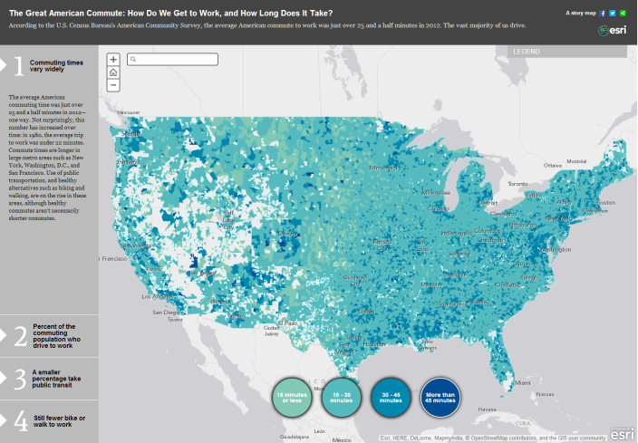
Figure 1 - The Great American Commute web map on ArcGIS Online
Esri Community Analyst Online/Business Analyst Online – How are Community Analyst online (CAO) and Business Analyst Online (BAO) different from ArcGIS Online? CAO and BAO are all about the data. These two applications are designed to help users find and display data based on common geographic units (e.g., states, counties, census tracts, etc.). Both web sites include a wide variety of data from the U.S. Census Bureau and other federal agencies, along with a rich collection of consumer purchasing and behavior data. And CAO/BAO will even subset out small sets of data which can then be used in ArcGIS Online maps! Access to a limited number of data variables is available for free using the same free accounts created for ArcGIS Online. For access to the full data catalog you will need an account created through the CSUSM Organizational Account.
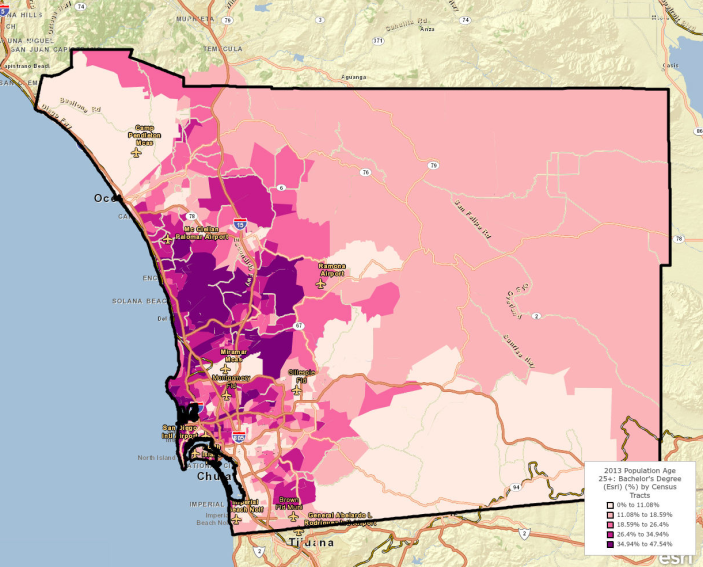
Figure 2 - Percent of Adults in San Diego County with Bachelor's Degrees - map produced
in Community Analyst Online
ArcGIS Desktop – ArcGIS Desktop software is a robust, feature-rich GIS software suite that is used in more than 300,000 organizations worldwide, including more than 7,000 colleges and universities. ArcGIS Desktop can be used to create maps and map data, analyze geographic data and prepare data for use with other software programs and platforms. ArcGIS Desktop is a complex software package, and while it is possible to learn it on your own it is typically recommended that new users receive some sort of formal training. Online training is available free from the Esri website after you login with your CSUSM credentials.
ArcGIS Desktop is available for CSUSM students, faculty and staff via CougarApps. Faculty and staff can install a single-use copy on their campus computer. In order to activate the authorization number an Esri Global Account is required (This is the same account that gives you access to ArcGIS Online and Community Analyst Online). These registration numbers are used to generate a license file that is valid for one year. Students can receive at 1-year free trial of ArcGIS Desktop software.
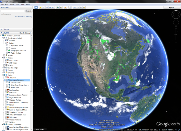
Google Earth – Google Earth is a wonderful tool for exploring the physical geography of Planet Earth, with 3D visualization tools that replicate the changing terrain as well as the buildings that man has placed on that terrain. Dozens of data layers are available that display information about points of interest, photos, scientific facts and information related to global awareness. Users can create and save their own map placemarks and create a virtual tour using these placemarks. Google Earth is installed on all computer lab computers and is available for installation on faculty computers.
GIS Data
SANGIS – SANGIS is a cooperative effort between the City and County of San Diego to maintain and provide GIS data related to San Diego County. There are over 250 data layers available, covering topics such as land use, geology, hydrology, public safety, business and health. Data files are available as ArcGIS shapefiles, which load easily into ArcGIS Desktop or ArcGIS Online.
State of California Geoportal – The California Geoportal provides easy and convenient ways to search, discover and use geospatial data resources. A primary goal of the California Geoportal is to improve access to California’s geographic data portfolio, and expand the creative use of those data resources. The California Geoportal strives to increase information transparency, and is committed to creating an open environment for accessing important government derived geographic data.
The National Map - As one of the cornerstones of the U.S. Geological Survey's (USGS) National Geospatial Program, The National Map is a collaborative effort among the USGS and other Federal, State, and local partners to improve and deliver topographic information for the Nation. The geographic information available from The National Map includes orthoimagery (aerial photographs), elevation, geographic names, hydrography, boundaries, transportation, structures, and land cover.
The Global Map - Global Map is a group of global geographic data sets of known and verified quality, with consistent specifications which will be open to the public. Global Map is considered a common asset of mankind, and will be distributed worldwide at marginal cost. These geospatial data sets are composed of the following thematic layers: elevation, vegetation, land cover, land use, transportation, drainage systems, boundaries and population centers. The data will be updated at approximately five-year intervals to facilitate the monitoring of changes occurring in the global environment.
ArcGIS Content – There is a large amount of public data available through ArcGIS Online. Basemaps, demographic data, imagery, you name it. Data available through ArcGIS Online can be easily incorporated into your ArcGIS desktop maps as well.
NHGIS – The National Historical Geographic Information System provides, free of charge, aggregate census data and GIS-compatible boundary files for the United States between 1790 and 2012.
Other Resources
Esri Educational Community website – This is a good starting point for exploring GIS resources that are available, such as data, tutorials, case studies, lesson plans and discussion groups.
Esri Educational Community blog – This blog is updated regularly with posts on a variety of topics, ranging from tutorials and sample lesson plans to technical notes on how to use ArcGIS.com and ArcGIS desktop.
USGS Undergraduate Education Resources – Not specifically about GIS, but a great collection of resources related to teaching about geospatial topics. Contains links to public data and curriculum examples.
Geographically-Integrated History – A Geographic Information Systems (GIS) Training Manual for Historians and Historical Social Scientists – A free manual for historians and social scientists interested in learning about GIS. Full of examples and exercises that use historical data, rather than the typical land-use or public works examples.