
 myCSUSM


Geographic Information Systems (GIS)
What is GIS?
A geographic information system (GIS) is a system that creates, manages, analyzes, and maps all types of data. GIS connects data to a map, integrating location data (where things are) with all types of descriptive information (what things are like there). This provides a foundation for mapping and analysis that is used in science and almost every industry. GIS helps users understand patterns, relationships, and geographic context. The benefits include improved communication and efficiency as well as better management and decision making.Learn more about GIS from ESRI.

Image Courtesy of Geological Society of America
Who Uses GIS?
While GIS technology is an obvious tool for geographers, a growing number of people from other disciplines are finding ways to incorporate GIS into their work. CSUSM faculty in the following subjects have incorporated GIS projects in their curriculm and research over the years: Liberal Studies (Geography), Sociology, Political Science, History, Kinesiology, Biology, Anthropology, Marketing, Visual & Performing Arts, Physics and Economics.
Learn Esri
All students, staff, and faculty have access to web based training in the Esri Academy and Learn ArcGIS websites.
Computer Software Access
ESRI has minimum requirements for the ArcGIS Desktop 10.8.2 and ArcGIS Pro 2.9 version. If your computer does not meet the minimum requirements, you can access the software on campus in SBSB 1108 during open lab hours or in the Student Open Computer Lab in the Library, Kellogg 2000. Current faculty, staff, and students can install the software on their personal computers. If you don't have a computer, you can check one out from IITS by completing the technology equipment request form.
ArcGIS Access
All current faculty, staff, and students can access the CSUSM ArcGIS Lab organization website to create maps. Follow this guide to login with your CSUSM credentials.
ArcGIS Survey 123
ArcGIS Survey123 is a simple and intuitive form-centric data gathering solution. Create, share and analyze surveys in just three easy steps. Use it to create smart forms with skip logic, defaults, and support for multiple languages. Collect data via web or mobile devices, even when disconnected from the Internet. Analyze results quickly, and upload data securely for further analysis. Explore the resources to get started today!
ArcMap Sunsetting
Esri software keeps up with the rapidly evolving and ever changing technology trends. ArcMap is being retired in 2026. "ArcGIS has evolved into a modern suite of apps - ArcGIS Online, ArcGIS Field Maps, ArcGIS Story Maps, ArcGIS Dashboards, ArcGIS Pro, and many others. Esri has recommended in recent years to educate and train students with the entire ArcGIS system, starting with SaaS technology where applicable, rather than ArcMap only."
CSUSM will continue to have ArcMap available during Fall 2022 and Spring 2023 semesters in the computer labs and available to download for personal computers. Contact the Campus GIS Specialist Michelle Kinzel for software download information.
Learning ArcGIS Pro
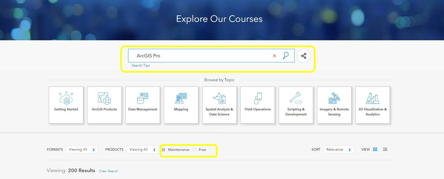
There are many resources to help guide you through this journey. All CSUSM faculty, staff and students have a wide range of web courses, seminars and videos that can help you learn how to use this software. Search the esri Training Catalog for 'ArcGIS Pro', and be sure to select the search option for Maintenance as shown below.
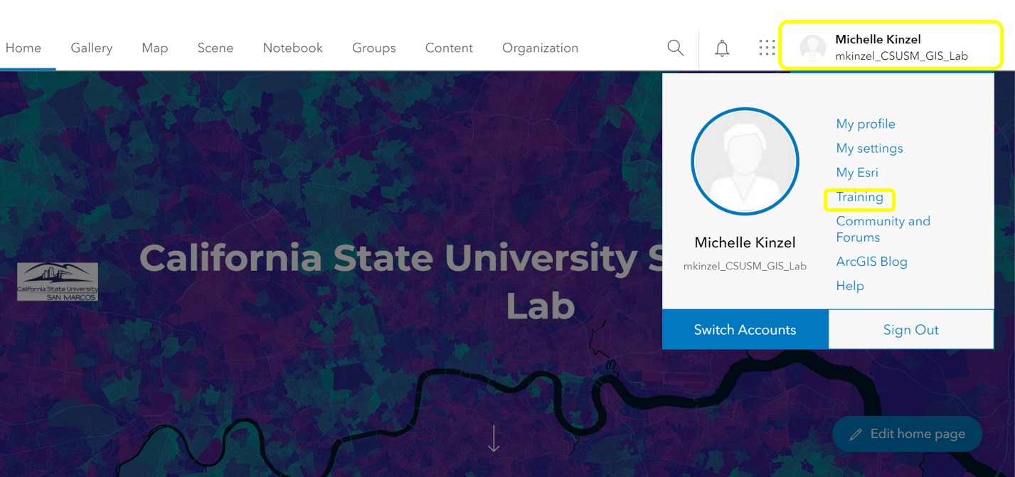
Training Options can be added to your CSUSM ArcGIS Online Account. Sign in through the CSUSM GIS Lab Page using a Single Sign On feature with your CSUSM credentials.
Once you have logged on, navigate to the Training section listed under your user name and add the resources you would like to explore to your account.
CSUSM Faculty have access to complimentary esri Press Books to use as consideration for teaching. Contact the CSUSM GIS Specialist Michelle Kinzel via email, mkinzel@csusm.edu, for directions on how to order your evaluation textbook copies.
GIS in the CSU
CSUSM partners with other CSU campuses to receive GIS software and support through the California State University GIS Specialty Center. Member CSU campuses participate in a software site license with Environmental Systems Research Institute (ESRI) for GIS software. The GIS Specialty Center promotes inter campus dialogue on teaching, research and application issues within the field of Geographic Information Science.